North End Resilience District: Green Infrastructure Master Plan (2023)
In the fall 2023 semester, Northeastern University School of Architecture joined the Envision Resilience challenge, partnering with the City of New Bedford, National Park Service and Groundwork Southcoast to work on park-level, street-level and neighborhood-level resilience design and planning. The teams focused on New Bedford, MA’s North End, a vibrant, dense neighborhood home to many Portuguese, Central and South American immigrants. More recently, the North End has been heavily impacted by deindustrialization and 20th century economic transitions from a whaling economy to a textile economy (the city is now heavily driven by commercial fishing and wind production), as well as the construction of Interstate 195 cutting off the neighborhood from downtown New Bedford. Now, a dense urban fabric of triple deckers, small businesses and neighborhood parks are facing increased resiliency challenges with Acushnet River flooding, a large quantity of impervious surfaces, a limited street tree canopy and unsafe conditions for pedestrians and cyclists on the neighborhood roads.
Master Plan
The three maps below illustrate the final master plan; the left map showing the project phasing (explained further in the narrative booklet below), the middle map showing the implementation map (with priority residential planting zones, primary rain collection streets/intersections and primary street tree planting corridors) and the right map showing the proposed active transportation network. The master plan aims to connect existing citywide planning efforts to create a network of safe, shaded streets that connect residents to neighborhood resources including schools, community centers and trails.


Narrative
See below for the narrative booklet guiding the background research, values and decision-making framework, community input into the master planning process, project phasing and street/intersection analysis. The third slide begins the cartographic analysis of the North End, studying first potential implementation sites (including municipal parking lots, streets and sidewalks, city buildings and city-owned vacant land, public and charter school properties, public housing and neighborhood parks), planning context, neighborhood assets (showing schools, churches, libraries and other key neighborhood centers), tree canopy and EJ analysis by census block, and finally water movement (showing sewer grates and the most heavily sloped, impervious streets over a topographic map). The fifth slide further details the project phasing, determined through the decision-making framework and including relevant streets and associated parcels. The sixth slide expands upon existing conditions and challenges, the elements of implementation that could address said challenges and the concerns that would be addressed. The final slides show the street analysis matrix that led to implementation decisions; for each key corridor, the team studied the number of driving and parking lanes, the sidewalk conditions, road slope, tree canopy, parking demand, street safety and the priority for each street: stormwater collection, pedestrian circulation or community development.


Implementation
See below for the implementation booklet which details the short-term and long-term toolkits as well as the plant selection toolkit. These strategies were developed for a short- to long-term implementation process, where the City of New Bedford and Groundwork Southcoast can implement more temporary public space interventions to help educate the public and gain community consensus around the reallocation of space. The City can later allocate funding and grant applications towards corresponding long-term intervention if the short-term intervention finds success. The planting toolkit was developed in close coordination with Groundwork Southcoast’s Stewardship Manager Margaret Broughton, who has completed many green infrastructure and tree planting projects in the city and knows what will most easily be approved by the City of New Bedford. Please view the toolkit slides to see the potential benefits of short- and long-term interventions as well as their estimated cost, necessary materials, construction/maintenance costs and lifetime, as well as long-term toolkit graphics detailing street green infrastructure and water movement. Please view the planting toolkit matrix to view tree, street tree, shrub and ground cover plants as well as their height, soil/water needs and purchasing cost.


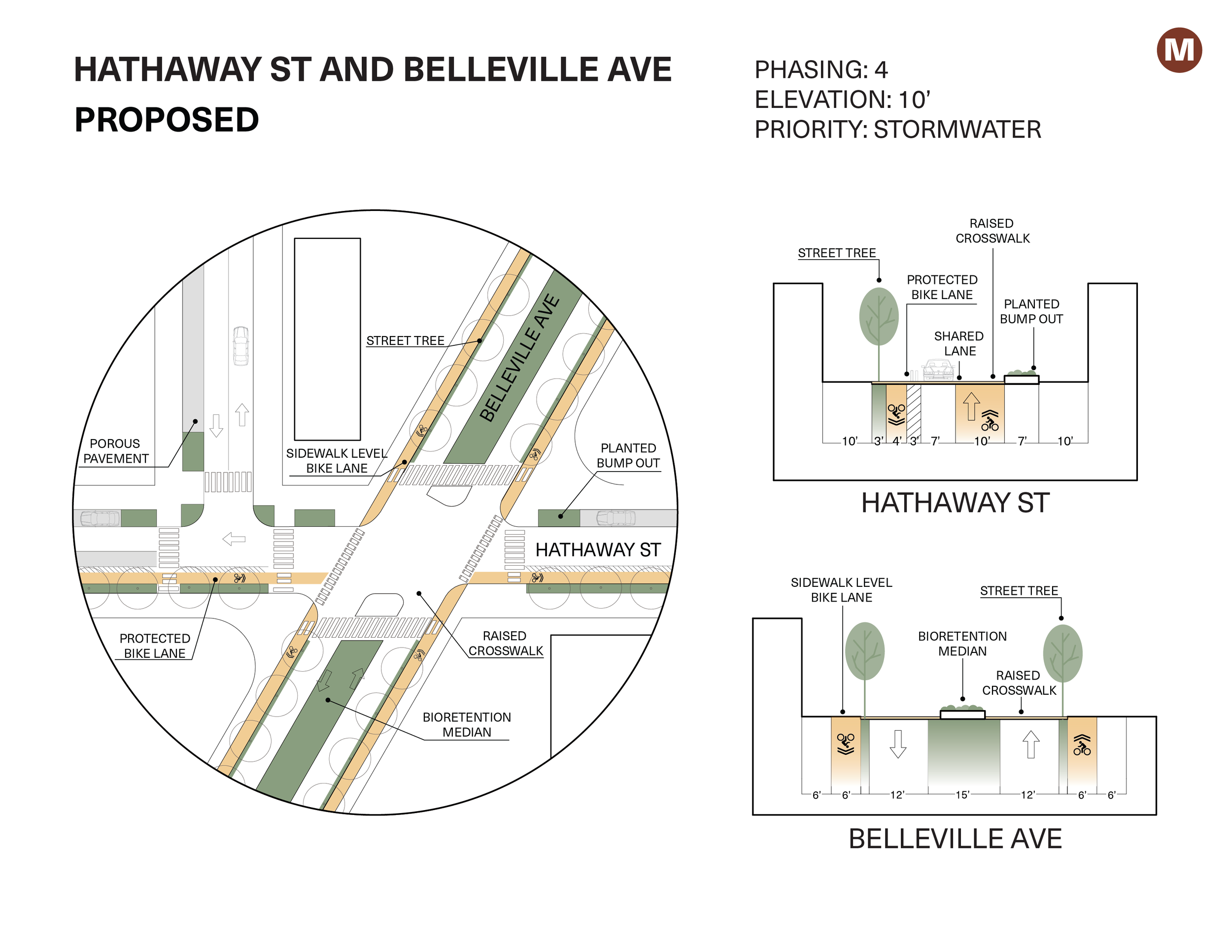
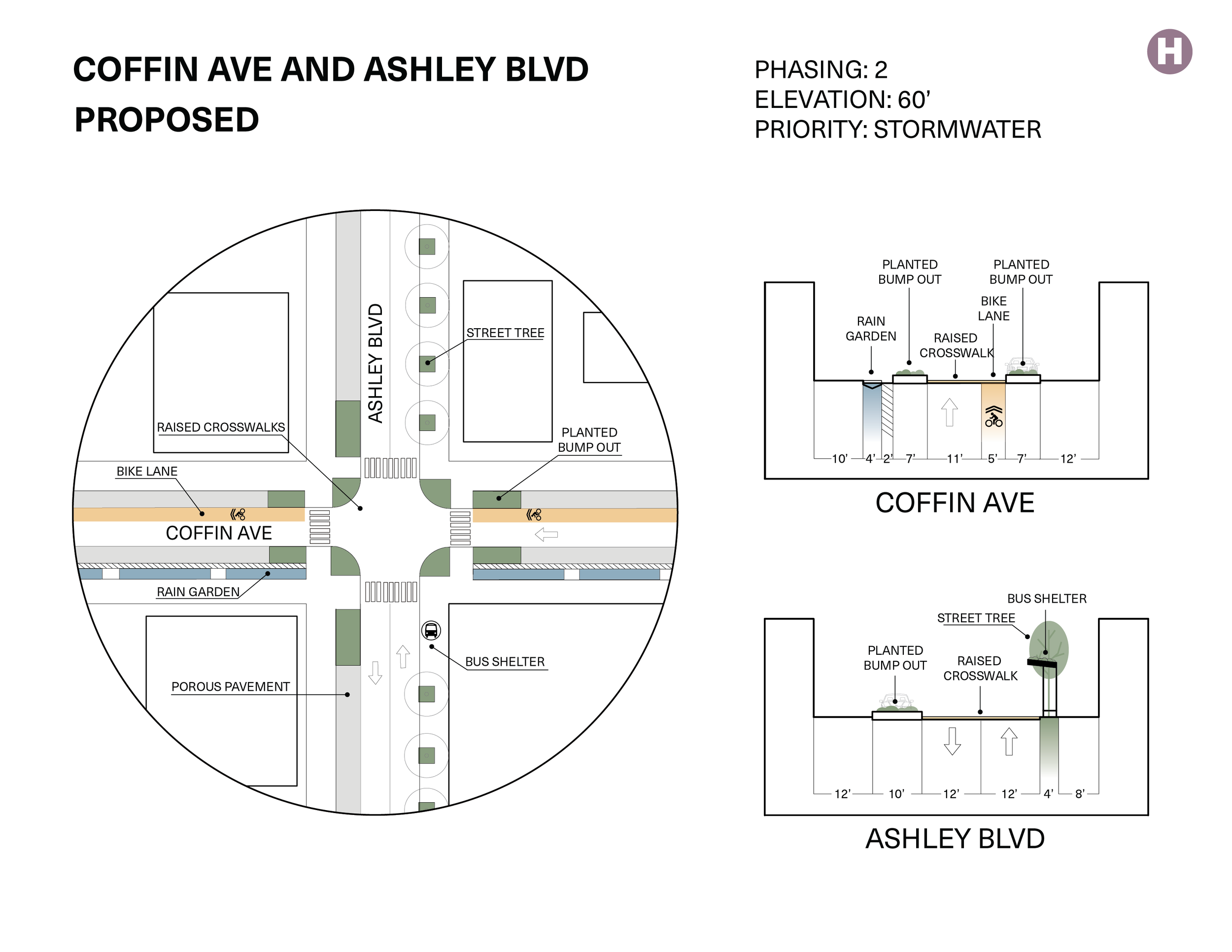
Intersection Overlays
To better illustrate the project phasing and street/intersection analysis from the narrative booklet above, our team drew key intersection existing conditions and a sample green infrastructure and transportation safety redesign. Please click through the slides to view four sample intersections that correspond with the master plan phasing map.