Daylighting the Stony Brook (2022)
The drawings below are part of a semester-long urban design project for ARCH 3170 Architecture, Infrastructure and the City. The following proposal, Daylighting the Stony Brook Culvert, illustrates the possibilities of converting surface-level parking lots in Mission Hill adjacent to the Roxbury Crossing MBTA station to a transit-oriented, mixed-use, dense network of buildings directly adjacent to the daylit Stony Brook that currently runs underneath the parking lots through a culvert. The river acts as an anchor for mobility, set up with multiple access points from the surrounding neighborhood to the park space with a variety of public spaces and pathways leading individuals to the transit hub. This project proposes a clear mission statement: urban design for mobility, public health, gathering, and environmental benefit. The following design objectives and guidelines were developed while designing the project and centered with each urban design decision.
Design objectives
Celebrate water: Use the new waterway to help clean the surrounding landscape, anchor gathering spaces across the fourteen acre site, and support food and energy autonomy.
Embrace sustainable transportation: Take advantage of the site’s proximity to the Roxbury Crossing MBTA station and active transportation methods and recognize the site as an incubator for improved urban planning in the neighborhood to reduce car dependency.
Mitigate extreme climate events: Use the unearthed landscape as a sponge for weather events by designing a water-holding system, limiting paved infrastructure, and collecting, filtering, and reusing water runoff from surrounding infrastructure. Design buildings to be flexible, adaptable, and supportive of surrounding green and blue infrastructure.
Program and policy guidelines
Preserve affordability: Develop the Roxbury Crossing Community Land Trust (CLT) to represent the residents of the site, ensure their ability to resist displacement, and work within rent-to-own models to transfer ownership from developers to tenants.
Retail spaces: Prevent big-box retail and corporate leases within all commercial areas. Uplift existing businesses and nonprofits in the area by providing them flexible, adaptable spaces. Utilize the road diet along Tremont Street to create a new commercial edge.
Open space: Extend Department of Conservation and Recreation (DCR) jurisdiction into Mission Hill towards Parker Street to ensure long-term green space preservation.
When conducting site research, I studied archival content of the Stony Brook collected by the Emerald Necklace Conservancy. I learned the brook once ran unearthed from Turtle Pond in West Roxbury to the Back Bay Fens, carrying unusually clear water that powered breweries and industry along its route for much of the 19th century. Common practice with many other Boston rivers, this section of the brook in the neighborhood of Mission Hill was culverted in 1888 directly underneath the project’s site, though just a few feet beneath the earth. This proposal is an aspirational study of the potential economic, environmental and community developmental benefits of unearthing urban waterways in Boston.

This render illustrates the Mission Hill Beach, one of the many unique public spaces along the daylit river. Stone steps bring individuals down the bank from the Southwest Corridor bicycle and walking trails to the river's edge, and a wooden boardwalk meanders below street-level stone bridges.

This render continues along the riverfront park to the north and east of the brook, showing the possibilities of walking directly from the riverbank to the new Roxbury Crossing Orange Line headhouse. The headhouse is oriented towards a circular pavilion which allows individuals to gather and observe the water emerging from the culvert, or for community events, concerts and festivals to take place.

This render illustrates the northwest corner of the site where the water re-culverts before exiting into the Back Bay Fens. Riverside docks and gently sloped riverbanks provide opportunities to spend time close to the water.

Existing conditions: This plan diagram illustrates the site as it appears today. The site is bound by Tremont Street to the south and east, Prentiss Street to the north and Parker Street to the west. The Southwest Corridor state-owned park and Boston/Providence rail corridor pass linearly through the site, which hosts large parking lots, undeveloped land, industrial buildings and an active commercial and residential corner in the southwest. The site is surrounded by some of Boston's first public housing developments to the north and west. The dotted pathway marks the culvert's current geography.

Proposed site plan: The river is shaped by the site's lowest topographical elevations with a vertical 15' between predicted water levels and the ground floors of buildings. The street grid is recreated across the site with pedestrian and bike-only streets helping connect the river with surrounding neighborhoods. The railroad is trenched and Southwest Corridor is moved above the trench, reactivating the Tremont Street edge. Surrounding streets are reconstructed using Complete Streets guidelines, and green infrastructure along street edges collects rainwater and carries cleaned runoff to the Stony Brook, creating distinct and functional water features.

Urban design framework: This diagram simplifies the previous plan, showing new and connected bicycle infrastructure in yellow, bus infrastructure in red, general purpose vehicle infrastructure in black, non-sidewalk pedestrian trails in gray (and riverfront boardwalk in tan), and the Stony Brook in blue.

Illustrative axonometric: This view shows building massing and other site details from a southeastern bird's eye perspective. Site topography elevates over the railroad trench and dips at the riverbank. Mimicking Boston's hilly landscape, gradual drumlins are located at each river curve, resulting in distinct public spaces. All proposed buildings are between four to six stories to add much-needed commercial and residential density while responding to surrounding riverfront and neighborhood contexts.
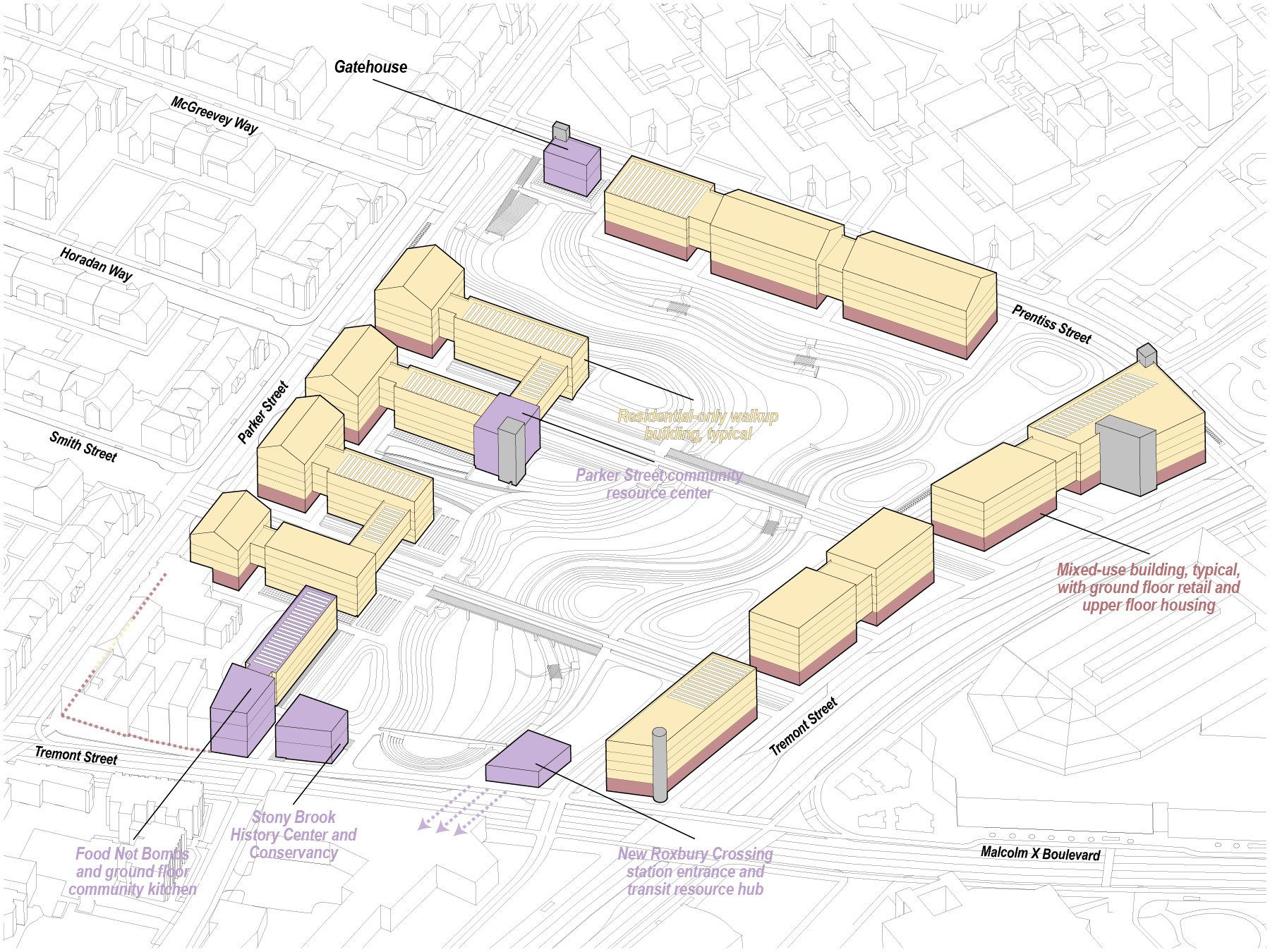
Program axonometric: This diagram simplifies the previous axonometric showing building use. Ground-floor commercial spaces ring each street edge while residential spaces stack above. Key cultural and community programmed spaces include the Parker Street resource center (preserving an existing mill building on-site), a new Roxbury Crossing headhouse, conservancy history center, food nonprofit and gatehouse (allowing park staff to close the culvert gate and let water pool in the Stony Brook basin in the event of storms or river activity programming).

Section A: This cross section slices through the site from north-south looking west. Each bisecting street is diagrammed below its cut showing adequate transit and active transportation priority as well as green infrastructure.

Section B: This cross section slices through the site from east-west looking north. Each bisecting street is diagrammed below its cut showing adequate transit and active transportation priority as well as green infrastructure. This section shows the new railroad trench with the relocated linear Southwest Corridor park above to maximize available park and building space.

Section transect: This axonometric drawing shows a more detailed view of how a typical building on-site would interact with the surrounding street, park and river. Resilient native plants line banks; each of the planted species is tolerant of both wet and dry conditions, allowing for a fluid river elevation. Additionally, parks have a slight slope allowing water to pool towards the river. The buildings are large, modular and brick, drawing inspiration from the original mill structures of the industrial landscape.

Transect design variants: This GIF animates different building design options for site buildings, detailing building balcony and public space opportunities, riverfront access (carefully coordinated with the State of Massachusetts' Chapter 91 Public Waterfront Access act) and building roof activation for residential common space.